05 geocoding es2c screen
Geocoding ES2C Screen
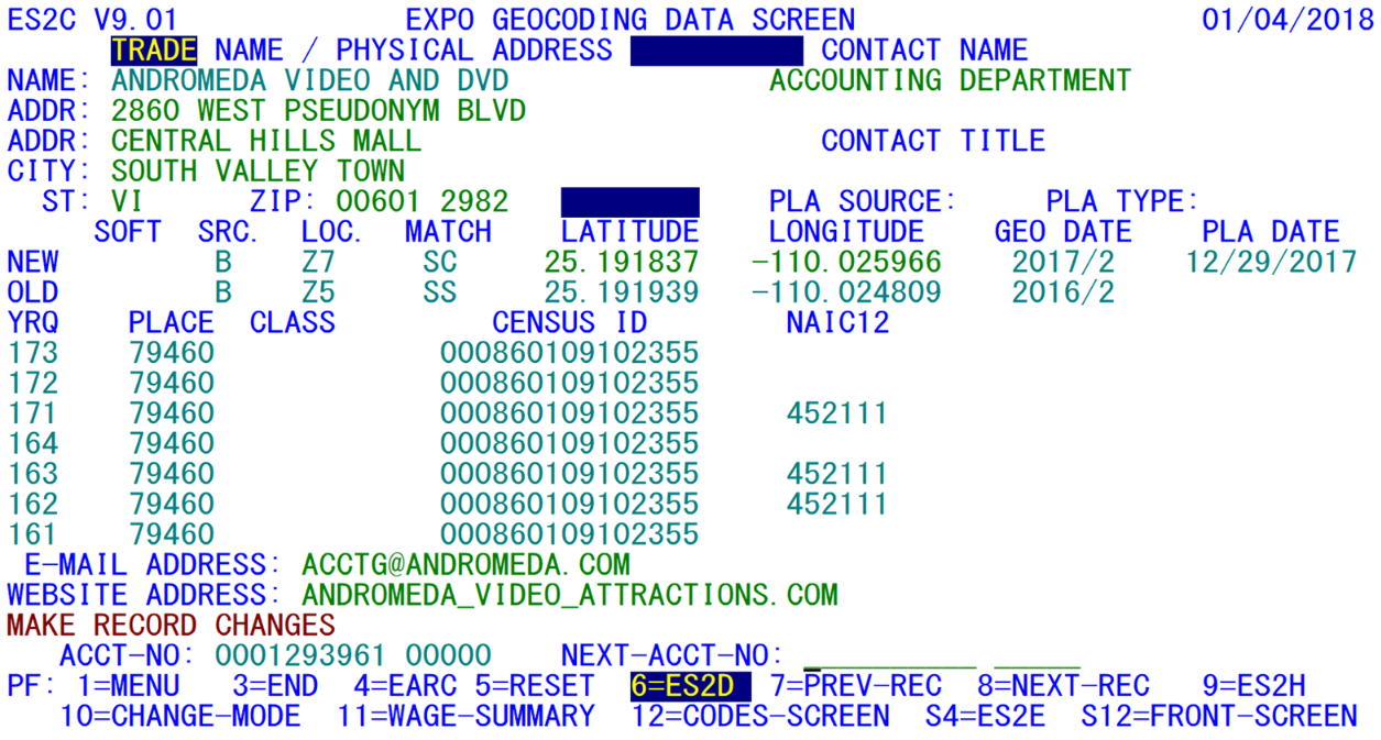
A sample of the Geocoding Screen appears below. It is controlled by the ESC3 transaction.
Besides showing geocoding information, the Geocoding Screen also shows contact information and the quarterly “NAICS12” code, which designates the final 2012-based NAICS code used at the end of the 2017 refiling cycle. This will be changed to “NAIC17” to indicate the final 2017 NAICS code in 2022. You will notice that there were a couple of quarters where this code appeared other than 17/1; that is due to testing, but the 22/1 code should only be populated for “NAIC17”.
This screen displays all of the information related to geocoding and physical address updates. Some of the geocoding fields are quarter-specific, while others are shown as “new” and “old” codes, such as the longitude and latitude. The latter group shows the current data as well as the most alternative values. The only key that can reach this screen from any other ES2C screen is the PF24/Shift-F12 key (usually the shift of PF12). It consists of three sections of data, as depicted in the sample. Each of these screen areas is described in the next paragraphs.
The top region of the screen shows the physical address block in the same format as in the first two screens. But no mailing or U-I address appears in the upper-right portion of the screen in this case. Of course, the physical location address is pivotal to geocoding information. Since BLS geocoding software reformats the physical location address (sending it to the IGT File), it was supposed to one day be available; this would eliminate much of the variability of abbreviations, etc., currently found quite commonly (“Av., Ave., or Avenue”, just as one sample). However, this will not be during the lifetime of EXPO.
Note: Due to certain inherent problems with the BLS geocoding software (such as failure to recognize suite numbers, etc.), along with the potential for misapplying an obsolete address (in case it was recently modified by hand), standardization methods from IGT data have not yet been implemented.
In the upper, right-hand portion of the screen are two fields with their own headings, namely the Contact Name and Contact Title. Formerly referred to as the “attention name”, the contact name is accompanied by the contact title; both fields can be collected on the annual refiling forms. There is not, however, an avenue for loading contact titles by batch, so they must be hand-entered if they are to be kept on this screen. The contact fields are stored in the “C”-type records of the MOA File.
The center area (displayed below) lists the administrative geocoding fields, including the software code, source code, location code, match code, latitude, longitude, geocoding date (i.e., year/quarter of longitude and latitude change), and physical location address (PLA) change date.
All of the fields except the PLA change date have two occurrences labeled “Old” and “New” (the PLA change date only appears once). The software code and source code fields describe how the data were obtained, rather than where the establishment is located. They serve two principal functions, either to note that BLS has produced the data, or that there were manual overrides introduced by the State to lock longitude and latitude values from machine-generated modifications.
These hand entries are generally derived from fieldwork, such as visiting the worksite with a Global Positioning System (GPS) unit for physically pinpointing the office. GPS devices generally have a precision on the order of a few feet, or to the nearest 100,000th of a degree of longitude and latitude. Since longitude and latitude are carried to the millionth of a degree (roughly the dimensions of a playing card when the long side is laid in a north-south direction), the geocoding system plans for subsequent improvements of GPS precision.
Geocoding updates act in a similar manner to the quarter shifting in Job 001Q. When new geocoding assignments are received in the Input Geocoding Transaction (IGT) File from BLS (through Job 035D), the previous values are transferred from the “New” to the “Old” fields, making room for the revised values (except for locked data described previously). The geocoding date is the year/quarter for which the codes were transferred in from BLS. This field is also automatically updated when geocoding (specifically geophysical — longitude and latitude) data are entered on this screen. The PLA date is the last date on which the physical location address was modified, either on-line or by batch.
Descriptions for several of the geographic codes are stored internally. The description appears by moving the cursor to the field and pressing the Enter key. Fields that are “clickable” include the location code, match code (if it begins with a letter), and the quarter-specific place code (which originally was called the “city code”), naming the community to which the establishment belongs.
Longitude and latitude are listed in degrees, out to six decimal positions. This provides an implied accuracy of +/- 2 inches in the north/south direction, generally +/- 1.5 inches in the east/west direction. This is an instance where the “accuracy” surpasses the precision, since it is not possible to confine the location of a large building to an area that is a small fraction (about 1/12) of a square foot. As the geocoding software is adjusted, some of the locations may be slightly redefined, as is noted in the sample account on the previous pages. The shifts noted here are still negligible, however, amounting to no more than several feet.
You will probably notice quickly that longitudes are listed as negative values. The reasoning for this is that western longitudes increase as you travel westward. Only negative numbers get larger on a chart as they extend to the left (west on a map), so using negative longitudes works best for graphical representations generated from geocode downloads. Positive values for latitudes work best for northern latitudes, which is the other field that is represented here.
The lower half of this screen begins by listing the quarter-specific fields associated with geocoding. These fields include the 5-digit place code, the 2-character class code (a sub-division or classification of the place code to denote urban, rural, etc., categories), and the 15-character census block. In earlier versions, there was a separate census tract field, but this was dropped, since the tract is part of the census block field. The census block is sub-divided as follows: the first two digits are the State FIPS code; the next three digits are the county FIPS code (which may or may not match the quarterly county code found on the Codes Screen); the next four digits are the census tract; the next two digits are a subdivision of the census tract, and the last four characters (sometimes blank) show the census block number within the tract:
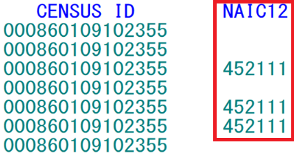
Obviously, the State and County ID portions would make sense for your State. For example, California may start with “06031”, which says that this is State FIPS Code “06” and county FIPS code “031”. The NAICS-2012 code appears after the census block (displayed below). This was added specifically for the 2017 refiling cycle; it denotes the final 2012-based NAICS code for the establishment at the completion of the refiling cycle. Every five years (2002, 2007, 2012, 2017, 2022, etc.), there is a revision of some of the NAICS codes; these codes are non-continuous. It replaced the now-defunct NSTA field (NAICS with a SIC Treatment of Auxiliaries). Although the SIC code is still present on the Micro File as an administrative data element, it is most often set to 9999, since data don’t go that far back for accounts that were acquired after 2000 (the last year when SIC’s were kept). We can be confident that the NSTA field will no longer be needed, since the auxiliary code has been dropped. Although the NAIC12 is shown here, it is expected that this field will remain generally blank. It is therefore not currently an updateable field.
The last two lines of enterable fields are the email address and website address of the employer. These fields were added to the refiling forms processing, so they are only updated at most once every three years. Email and website address data are stored in the Micro Omni Auxiliary (MOA) File. They provide additional contact avenues for the QCEW analyst to help track anomalies in employment or wage data, either by calling in the company website for notes of business expansion or contraction, or by emailing a contact person at the employer. Since both fields normally appear in lower-case characters, the Geocode Screen has been equipped with the ability to accept mixed-case entries (however, only these two fields accept lower-case entries; the rest are converted to upper-case values). Apart from the ES2U publication parameter entry screen, this is the only lower-case entry allowed in EXPO.
The function key definitions are the same as those used on the Codes Screen. The F10 key is again used to toggle between inquiry and change mode; all ES2C screens can switch to the ES2E screen via the PF16/Shift-F4 key. You can transfer to the Front Screen by pressing the PF24/Shift-F12 key, to the Codes Screen with the F12 key, or to the Wage Summary Screen via the F11 key.
Related Links


