14 job 035d process igt data micro file
Job 035D - Process IGT Data into Micro File
Job 035D processes the Input Geographic Transaction (IGT) File into the Micro File. The IGT was developed by BLS to transfer geocoding data from the National Office to the State Micro File. The National Office processes the EQUI deliverable, translating all provided physical location addresses into geographic information (longitude and latitude, place code, census block, and various code values); these are sent back to the State by EUS Direct or on a “CENCO” file on the DMA mainframe.
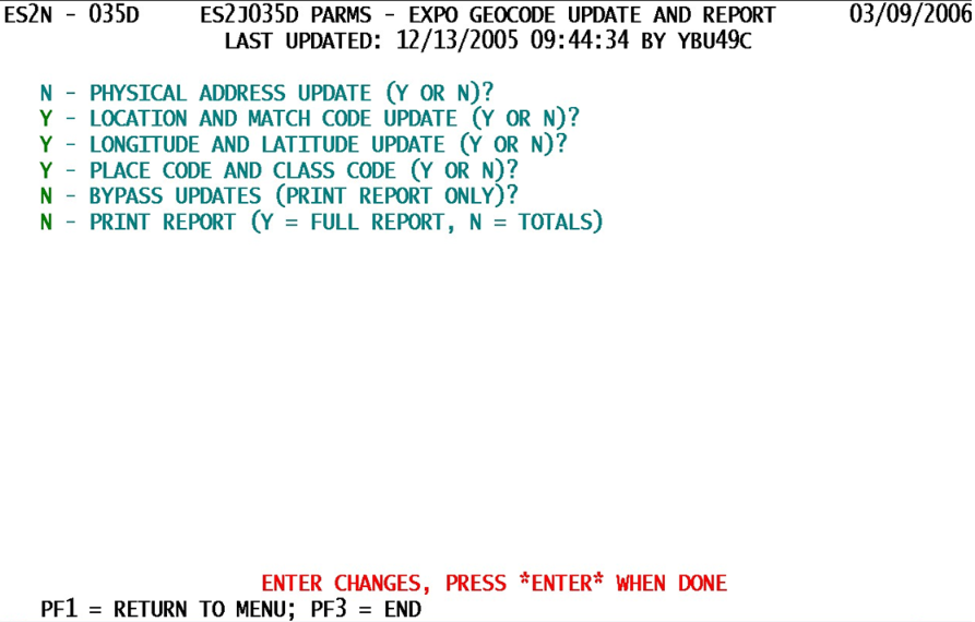
One unique feature of this screen becomes obvious very quickly. The first parameter (for physical address updates) is inactive (colored turquoise (fixed) rather than green (updateable)). Shortly after this job was released, it was found that certain aspects of address realignment were incomplete in the National Office system. Primarily, extensions such as a suite number were erased, removing valuable information if applied to the micro data. There are also concerns that more recent PLA changes may have been enacted in the State, making the returned PLA obsolete. Until and unless these issues can be resolved, the PLA-update option will continue to remain locked. Here are all of the screen parameters, which are all yes-or-no options.
1. Physical Address Update (Y or N)? - This field, as noted above, is permanently set to “N” (for no update to the physical location address allowed). It was intended to allow the reformatted PLA data (with standardized abbreviations, spacing, etc.) to be transferred to the micro data along with the other geocoding fields. This function may be restored if safe and accurate updating can be assured in the future.
2. Location and Match Code Update (Y or N)? - This is an option to modify the location code and match code from BLS-derived values. The location code shows the level of geocoding accuracy available for the address (ZIP+4 centroid, actual street placement, etc.), while the match code denotes the type of grouping (urban, rural, airport, etc.).
- a. ‘Y’ (“Yes”) - Allow these two fields to be modified from BLS data.
- b. ‘N’ (“No”) - Prevent updates to location and match code data.
3. Longitude and Latitude Update (Y or N)? - Of course, this is the option to update geographic longitude and latitude locations. If the physical location address is trustworthy, there is generally no reason not to update these fields. Longitude and latitude are stored to the nearest one-millionth of a degree, or an area roughly the dimensions of a standard playing card. If alternative sources have been used to verify longitude and latitude, such as hand-held Global Positioning System (GPS) devices, then these updates can be blocked as well.
- a. ‘Y’ (“Yes”) - Permit updates to occur to the longitude and latitude values for these establishments.
- b. ‘N’ (“No”) - Prevent any longitude or latitude updates from occurring.
4. Place Code and Class Code (Y or N)? - By this point, you get the picture that these are all “update” options, so the word update has been dropped. This option allows place codes (once called “city” codes) and their associated place-class code values to be updated. Place codes are 5-digit numeric values that specify what the community or locale name is. The class code notes whether this is an urban or rural district, as well as other classifications. Normally this field will match the longitude and latitude update option.
- a. ‘Y’ (“Yes”) - Allow place codes and place-class codes to be modified.
- b. ‘N’ (“No”) - Deny access to place code and place-class code updates.
5. Bypass Updates (Print Report Only)? - Here is an option that trumps all of the others just described. If this switch is set to “Y”, none of the other update switches matter, since no geocoding fields will be updated. This option relies upon the report printing to provide sufficient information to determine which updates to allow or disallow.
- a. ‘Y’ (“Yes”) - Do not update any geocoding fields on the Micro File; instead, produce the report by itself to give guidance as to whether geocoding fields can be updated (as with a follow-up run with the options changed).
- b. ‘N’ (“No”) - Allow any of the selected updates (as noted in the previous options) to be enacted; do not prevent these updates from occurring.
6. Print Report (Y = Full Report, N = Totals Only) - This option acts as a yes-or-no question, but doesn’t carry a question mark. It should be chosen with caution, since it could make the entire process useless. If the bypass-updates option (just mentioned) is set to “Y”, and this print-report switch is set to “N” (totals only), then the job is wasted, since the summary totals don’t help the updates and the non-updates can’t substitute for the absent report. Avoid instances of the “Y”/”N” combo.
- a. ‘Y’ (“Yes”) - Produce the detailed report, showing all geocoding fields available for establishments with physical location addresses present.
- b. ‘N’ (“No”) - Provide only the summary totals as a report substitute.
This report / update process can be run at any time, but requires the presence of an Input Geocoding Transaction (IGT) File. Normally these files are available shortly after the EQUI clean-up has been completed at the National Office.
Related Links
